


I. Introduction
Global soil moisture mapping using space-borne synthetic aperture radar (SAR) has been widely attempted because of its importance in global water and energy fluxes, weather and climate forecasts, flood prediction, and drought monitoring [1]. Global mapping of vegetation parameters using space-borne SAR imagery is also a very important remote sensing technique for land classification, estimation of productivity and biomass, and remote sensing of environmental changes [2]. The global mapping of soil moisture or vegetation parameters for vegetation fields is, however, still a challenge because of its complexity. Recently, Sentinel-1 SAR (5.4 GHz) and Radarsat-2 (5.4 GHz) have continually provided SAR images for land monitoring. A simple and accurate scattering model for radar backscatters of vegetation fields at 5.4 GHz would be very helpful for estimating the vegetation biomass and soil moisture of a vegetation field from its SAR image.
The radiative transfer technique has been widely used for developing microwave scattering models for vegetation fields [3, 4]. The radiative transfer model (RTM) has good accuracy for estimating backscattering coefficients for a wide range of vegetation canopies [5–7]. However, RTMs have a main drawback for practical usage: the models usually have several dozens of input parameters.
The water cloud model (WCM) is much simpler than the RTM because it has only two terms (the direct backscatter from a vegetation layer and the direct backscatter from the underlying surface with round-trip attenuation from the vegetation layer), ignoring the interaction between the vegetation crown and the the underlying ground surface [8, 9]. Although the direct backscatter of a soil surface can be quite accurately obtained using theoretical or empirical models [10, 11], the constant parameters for the direct backscatter and the attenuation of the vegetation layer should be determined empirically for each frequency, incidence angle, polarization, and type of vegetation, which is the main disadvantage of this model.
In this study, we focus on developing a simple and accurate model for multi-polarized backscattering coefficients of vegetation fields at 5.4 GHz. Transmissivity through a vegetation layer depends on radar frequency, incidence angle, and biomass (or leaf-area index [LAI]) [12]. The effect of vegetation on soil moisture retrieval decreases with a decrease in incidence angle and a decrease in biomass [12, 13]. We develop a simple empirical scattering model for vegetation fields using an extensive database that includes the results of the modified RTM in [7] for various vegetation fields, scatterometer data, SAR data, and in situ measured ground-truth datasets. Finally, the new empirical model is verified with independent Sentinel-1 SAR data and the corresponding in situ measured ground-truth data.
II. Development of a Simple Model
To develop an inversion algorithm to retrieve soil moisture or biomass from radar measurements, we may need to have a simpler model than the complicated RTM model with its many input parameters—about 60 input parameters in [5] and 32 input parameters in [7]. One candidate for a simple model for an inversion algorithm would be WCM [8], which was proposed four decades ago with the following form, ignoring the interactions between the vegetation layer and the underlying soil surface:
with
where
σ t , p q o σ v e g , p q o σ s o i l , p q o T p q 2
Because the primary purpose of this simple model is to apply it to inversion algorithms for the global or regional mapping of soil moisture or biomass using SAR data at 5.4 GHz, we chose biomass Bm (kg/m2) among other parameters for the vegetation parameter V. The transmissivity is
1 ( T p q 2 = 1 ) ( T p q 2 ≈ 0 ) ( 1 - T p q 2 ) V 1 ( 1 - T p q 2 )
where a0, a1, and a2 are constant parameters to be determined for a given frequency and
σ s , p q o
In this study, we use the PRISM (polarimetric radar inversion for soil moisture) [4, 11] to estimate
σ s , p q o
where p and q are the co- and cross-polarized ratios, k is the wave number, hrms is the root mean square (RMS) surface height, Γo is the reflectivity at the nadir direction
Γ 0 = ∣ ( ɛ r - 1 ) / ( ɛ r + 1 ) ∣ 2
Γv = |(ɛrcosθ – C1)/(ɛrcosθ + C1)|2, Γh = |(cosθ – C1)/(cosθ + C1)|2 with Γh = |(cosθ – C1)/(cosθ + C1)|2. The dielectric constant ɛr can be obtained using empirical formulas in [14] for a given volumetric soil moisture content mv (cm3/cm3).
The unknown parameters of the simplified WCM in (4) can be obtained using other theoretical, numerical, and experimental datasets with various biomass values for a given frequency and vegetation type. In this study, we focus only on the frequency of 5.4 GHz and one-layered vegetation fields, such as meadows, rangelands, pastures, and farming land, including arid and semiarid areas. We also consider only a relatively narrow range of incidence angles, 20° ≤ θi ≤ 50°, mainly considering the operating modes of Sentinel-1 SAR and Radarsat-2. Because one of its main applications may be an inversion algorithm for soil moisture retrieval, the biomass range of 0 ≤ Bm ≤ 5 kg/m2 is primarily selected in this study, considering the validity regions of soil moisture retrieval for vegetation fields [13].
To determine the unknown constants in (4) at 5.4 GHz, first, an extensive database of polarimetric backscattering coefficients for various vegetation fields at 5.4 GHz is generated using the modified RTM for various biomass values and soil moisture conditions: 0 ≤ Bm ≤ 5 kg/m2 with a step of Bm, ΔBm = 0.25 kg/m2, at mv = 0.03, 0.08, 0.13, 0.18, 0.23, 0.28, and 0.33 cm3/cm3, and at θi = 35°.
Subsequently, the nonlinear data fitting technique was used to empirically determine the optimum values of a0, a1, and a2 by comparing the modified RTM and the simplified WCM at each soil moisture condition. First, by comparing the backscatter from the underlying soil surface with the RTM and the corresponding term of the WCM, the values of the unknown constant a2 were obtained with the best fitting between the RTM and the WCM for various conditions. Second, the unknown constants a0 and a1 were also obtained by comparing between the RTM and the WCM for various conditions. Finally, the unknown constants a0, a1, and a2 were fitted with the first-order linear polynomials for the soil moisture content mv.
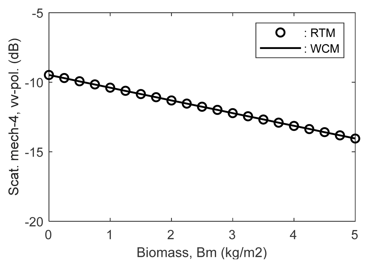
Fig. 1 shows the comparison between the simplified WCM and the corresponding term of the modified RTM for the direct backscatter from the underlying soil surface with the attenuation through the vegetation layer, with a2= 0.172 for VV-polarization at mv = 0.18 as an example. The estimated a2 values are approximately 0.17 for all polarizations and moisture conditions.
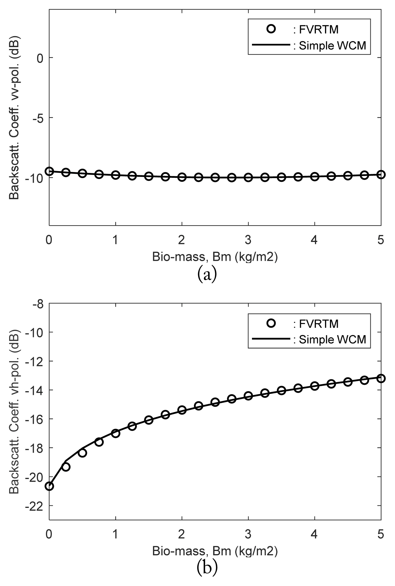
Fig. 2 shows the comparison between the modified RTM and the simplified WCM for VV- and VH-polarizations at mv = 0.18 cm3/cm3 and θi = 35°. For this fitting, a0 and a1 are 0.0163 and 0.994 for VV-polarization, 0.0225 and 0.902 for HH-polarization, and 0.0164 and 0.759 for VH-polarization.
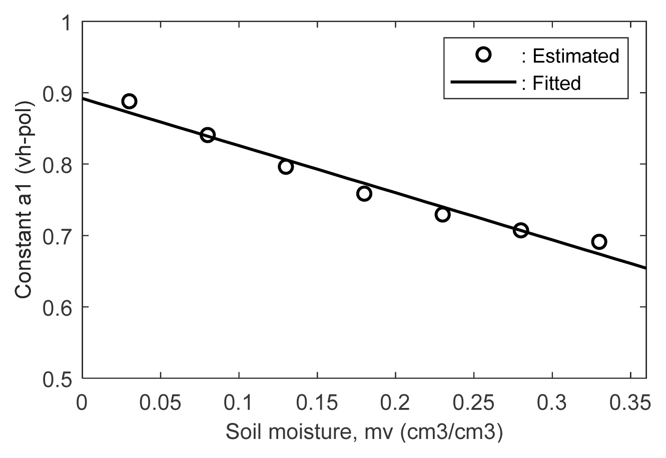
Among the three polarizations, the variation in the unknown constants a0 and a1 over the change of soil moisture is minimal for VV-polarization and maximal for VH-polarization. For example, the ratios of the constant a0 at mv = 0.33 cm3/cm3 to a0 at mv = 0.03 cm3/cm3 are about 1.02 for VV-polarization, 1.37 for HH-polarization, and 2.39 for VH-polarization. As an example, Fig. 3 shows the comparison between the estimated values and the best fitting line for the unknown constant a1 for VH-polarization. The best-fitting lines are given by a1 vh = −0.66 mv + 0.89 for VH-polarization, as shown in Fig. 3. The other relationships between the unknown constants and the soil moisture content are a0,vv = 0.0013 mv + 0.0160 and a1,vv = −0.026 mv + 1.00 for VV-polarization, a0,hh = 0.024 mv + 0.0181 and a1,hh = −0.32 mv + 0.96 for HH-polarization, and a0,vh = 0.047 mv + 0.00814 for VH-polarization. The angular dependency of the direct vegetation layer backscatter term is mainly controlled by cosθi in (4 ); therefore, the parameters are not sensitive to the incidence angle in a narrow range of incidence angles, 20° ≤ θi ≤ 50°.
In summary, the new empirical model has the following form for the multi-polarized backscattering coefficients of singlelayered vegetation canopies at 5.4 GHz.
where the pq-polarized backscattering coefficient of the underlying soil surface
σ s , p q o
III. Verification of the New Simple Model
Fig. 4 shows the comparison among the total backscattering coefficient
σ t o σ v e g o T 2 σ s o i l o σ s o i l o
The soil surface direct backscatter is dominant for lower biomass, while the vegetation layer direct backscatter is dominant for higher biomass, as shown in Fig. 4. The sensitivity of the radar backscatter to the vegetation biomass for cross-polarization is much higher than for co-polarization: e.g.,
σ v e g o T 2 σ s o i l o
Fig. 5 shows a comparison between the scatterometer measurements and the simple empirical model for the multipolarized backscattering coefficients of a full-grown cornfield at 5.4 GHz. The simple empirical model agrees quite well with the HPS measurements of a cornfield at the incidence angles of 20° ≤ θi ≤ 50°, as shown in Fig. 5.
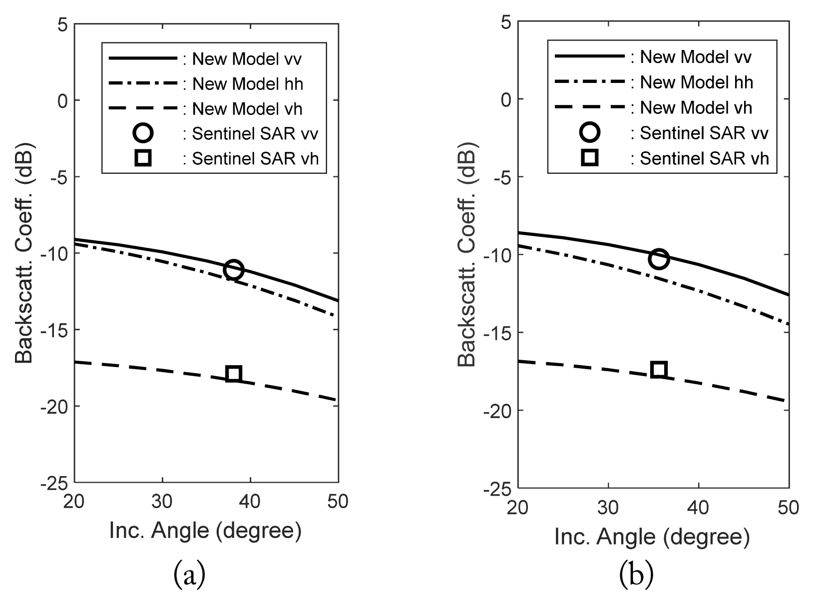
For further verification of the new empirical scattering model, we acquired Sentinel-1 SAR data and in situ measured groundtruth data. Fig. 6 shows the comparison between the Sentinel-1 SAR datasets and the new simple empirical model for rangelands in Bet Shemesh and Haifa in Israel.
We acquired the dual-polarized (VV- and VH-polarized) backscattering coefficients of the two test sites (rangelands in Bet Shemesh and Haifa, Israel) on February 23, 2019, with Sentinel-1 A in interferometric wide-swath (IW) mode. We also collected the biomasses, volumetric soil moisture contents, and surface RMS heights of the sites on February 23, 2019. The biomasses were 0.65 kg/m2 and 0.43 kg/m2, the moisture contents were 0.24 cm3/cm3 and 0.34 cm3/cm3, the surface RMS heights were 0.7 cm and 0.6 cm, and the incidence angles were 38.1° and 35.6° for the Bet Shemesh and Haifa sites, respectively. The empirical model again agrees quite well with the independent datasets of Sentinel-1 SAR. The new empirical scattering model is now proven to have good accuracy in predicting multipolarized backscattering coefficients of one-layered vegetation canopies at incidence angles of 20° ≤ θi ≤ 50° at 5.4 GHz, although the model is very simple, with only four input parameters.
IV. Concluding Remarks
First, an extensive database was generated for multi-polarized backscattering coefficients at 5.4 GHz with a modified RTM for various vegetation fields with wide ranges of input parameters. The database also included the scatterometer and SAR measurements, as well as in situ measured ground-truth data.
Second, the functional form of the WCM was further simplified according to the behavior of the backscattering coefficients in the database. The unknown constant parameters of the simplified WCM were then empirically obtained for each soil moisture condition by data-fitting between the database and the model.
Finally, the new empirical scattering model for multipolarized backscattering coefficients of a one-layer vegetation canopy at 5.4 GHz was analyzed with close examinations and verified with scatterometer and SAR datasets with in situ measured ground-truth data. It was found that the new empirical model agrees well with the experimental data as well as with the RTM. This new empirical model might be good for estimating the backscattering coefficients of one-layered vegetation fields at 5.4 GHz in the range of 20° ≤ θi ≤ 50° for VV-, HH-, and VH-polarizations.
The new model has a major advantage for being applied to any inversion algorithm because the model has only four input parameters: the incidence angle, soil moisture content, surface RMS height, and vegetation biomass. Therefore, the soil moisture content and the surface RMS height can be simultaneously retrieved from a dual-polarized SAR dataset upon being informed of the vegetation biomass, which can easily lead to the global or regional mapping of soil moisture using SAR images at 5.4 GHz.